

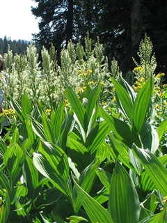
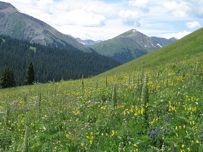
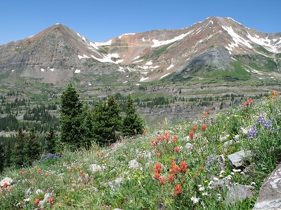
Hasley Basin on August 14th.
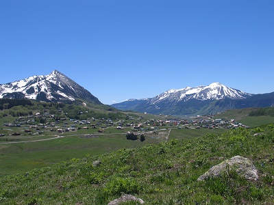
Hiking Through Wildflower Season in the Gunnison Valley
Where and when I took the photographs
Crested Butte was named the Wildflower Capital of Colorado for good reason, the wildflower displays can be kaleidoscopic if you are in the right place at the right time. The elevation and latitude make for a short, intense growing season but some wildflowers can be found blooming as early as April and others in late August. July is the peak blooming time, which is when the Crested Butte Wildflower Festival takes place. There are many books and web sites that describe the hiking trails in the valleys and mountains around Crested Butte, but wildflowers are usually mentioned only as something to be seen on the hike, without specifics. Here I am presenting hikes with the emphasis on the wildflowers; where to find them and when you can expect to see them blooming. I have identified 80 to 100+ species on some of these trails. Of course, nothing is guaranteed, thanks to Mother Nature and, unfortunately, climate change. See Life Zones for descriptions of the life zones in the Valley. Most of the trails are out and back, so you can turn around whenever you want. Gunnison National Forest has many more trails than those listed here. At the end of each trail is a link to up-to-date details and reviews of the trail, and many others in the area, from TravelCrestedButte.com and AllTrails.com. You can use your browser's print function to print this page. A scale of 70% or "Fit to Page" and "Portrait" prints a hike neatly on one page.
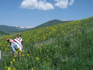 This page is dedicated to my dear hiking buddies, Carole and Joannie,
and their dogs whom I loved like my own. We hiked many happy miles on these trails together.
This page is dedicated to my dear hiking buddies, Carole and Joannie,
and their dogs whom I loved like my own. We hiked many happy miles on these trails together.
Here they are on the flanks of Crested Butte Mountain
on July 15th
Almont Triangle

Distance:
Up to you
Difficulty:
Moderate
Trail Type:
Out and back
Elevation Gain:
500+ feet
Starting Elevation:
8,632 feet
Popularity:
Minor
Best time for flowers:
May, June
Getting there:
Coming from Gunnison or Crested Butte on 135 turn at Jack's Cabin and drive toward the Taylor River.
After about 4 miles park at the crest of the ridge.
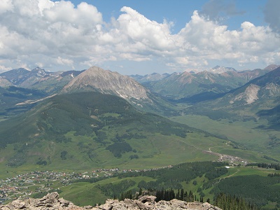
Up on the Triangle you can see the San Juan Mountains to the southwest, the Elk Mountains and the Castles to the west and Paradise Divide and Crested Butte Mountain to the north. It is a land of sagebrush, largely treeless, but for the solitary Ponderosa Pine or patch of Aspen. Because of its lower elevation the flowers bloom earlier and are more abundant in the spring than the summer. From the parking spot on Jack's Cabin Cutoff you can walk on old dirt roads as far as you wish either to the north, toward Round Mountain, or south toward Almont. Both will give you great views and flowers blooming amongst the sagebrush.
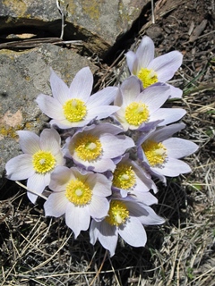
 Flowers will be blooming as early as April. One of the first to appear when the snow begins to
melt is the Pasque Flower, often in masses.
You may also see Showy Easter Daisy, Sagebrush Buttercup, Elegant Cinquefoil, Rock
Jasmine, Blue-eyed Mary and Carpet Phlox.
In May you will see Sugar Bowls, Drummond's Milkvetch, Mountain Candytuft, White Evening Primrose, Wallflowers, Scarlet Gilia, Slender Woodland Stars and Serviceberry in bloom.
At the end of May carpets of golden Arrow-leaved Balsamroot brighten the hillsides.
June brings Golden Banner, Scarlet Globemallow, Yellow Stonecrop, Wild Geranium, Sticky Gilia.
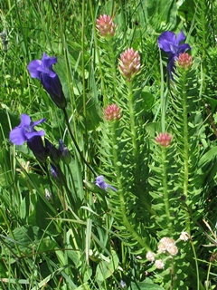
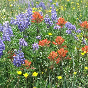
In July bright Lambert's Locoweed, Creamy Buckwheat, Penstemon and Indian Paintbrush contrast with the sage.
Flowers will be blooming as early as April. One of the first to appear when the snow begins to
melt is the Pasque Flower, often in masses.
You may also see Showy Easter Daisy, Sagebrush Buttercup, Elegant Cinquefoil, Rock
Jasmine, Blue-eyed Mary and Carpet Phlox.
In May you will see Sugar Bowls, Drummond's Milkvetch, Mountain Candytuft, White Evening Primrose, Wallflowers, Scarlet Gilia, Slender Woodland Stars and Serviceberry in bloom.
At the end of May carpets of golden Arrow-leaved Balsamroot brighten the hillsides.
June brings Golden Banner, Scarlet Globemallow, Yellow Stonecrop, Wild Geranium, Sticky Gilia.
In July bright Lambert's Locoweed, Creamy Buckwheat, Penstemon and Indian Paintbrush contrast with the sage.
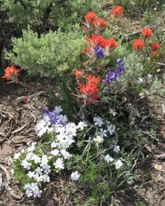
Photo: Desert Paintbrush, Larkspur and Phlox, May 27th.
Photo: Lambert's Locoweed, July 10th.
Some flowers that are found at this elevation in a sagebrush environment.
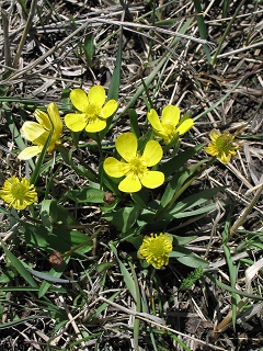
Sagebrush Buttercup, April 7th
Pasque Flower, April 23rd
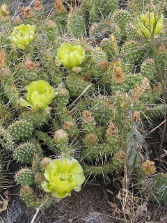
Prickly Pear Cactus, June 26th
Lower Loop and Upper Lower Loop
Distance:
4.6 miles
Difficulty:
Easy to moderate
Trail Type:
Out and back or loop
Elevation Gain:
337 feet
Starting Elevation:
8,904 feet
Popularity:
Very popular, look out for mountain bikers
Best time for flowers:
June, July
Getting there:
Butte Avenue in the NW corner of Crested Butte turns
into a dirt road called the Peanut Lake Road. There is a well-marked
parking area on the right.
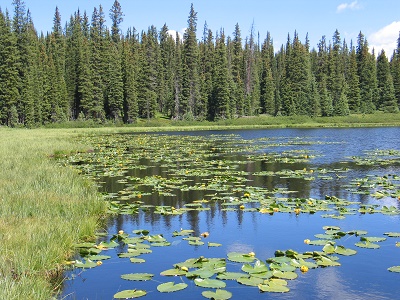
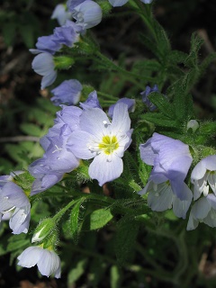
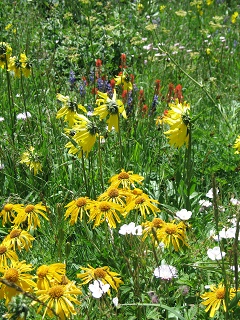
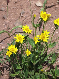
I take my visitors who live at sea level on this hike to help them adjust to the area’s higher altitudes. It is a gentle walk above the Slate River past Peanut Lake and the Gronk, the remains of a coal tipple, with beautiful views up the valley to Paradise Divide and across to Gothic and Crested Butte Mountain. The Lower Loop trail is fairly flat and connects with other trails. The Woods Walk from town joins the start of the trail and a trail to the Gunsight Pass trailhead extends beyond the end. It can be out and back but it can be a loop by taking the Upper Lower Loop trail which ascends to the left and winds through aspens about midway. Once the snow begins to melt in June, the flowers start blooming. One year on a hike at the end of June I identified 86 species; these are some of the less common flowers you will see.
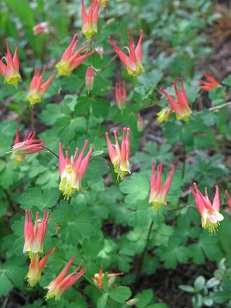 The beautiful
blue Colorado Columbine is the State Flower of Colorado and quite
commonly seen (see Poverty Gulch below). Less common is the Red Columbine found growing in the
shade of forest edges. Sometimes they get together to produce a pink
hybrid.
The beautiful
blue Colorado Columbine is the State Flower of Colorado and quite
commonly seen (see Poverty Gulch below). Less common is the Red Columbine found growing in the
shade of forest edges. Sometimes they get together to produce a pink
hybrid.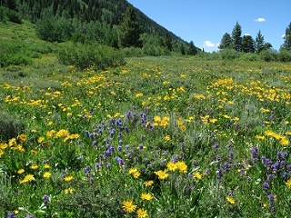 The Curlyhead Goldenweed is often called a Sunflower
and easily confused with Sneezeweed. Although in the
same family it is a distinctly different species. Colorado has many species of Penstemon;
the compact purple flowers of Rydberg's Penstemon are one of the less common;
it grows in abundance on this trail.
The Curlyhead Goldenweed is often called a Sunflower
and easily confused with Sneezeweed. Although in the
same family it is a distinctly different species. Colorado has many species of Penstemon;
the compact purple flowers of Rydberg's Penstemon are one of the less common;
it grows in abundance on this trail.
Photo: Curlyhead Goldenweed & Rydberg's Penstemon, July 15th Photo: Red Columbine, June 4th
These beauties are found in moist soil.

Little Elephant Heads, July 15th
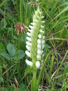
Ladies Tresses, July 28
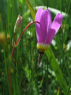
Shooting Star, June 4th
Snodgrass Mountain
Distance:
3.3 miles
Difficulty:
Easy
Trail Type:
Loop
Elevation Gain: 300 feet
Starting Elevation:
9,575 feet
Popularity:
Moderate
Best time for flowers:
June, July
Getting there:
Drive through Mt. Crested Butte on the Gothic Road. On the left you will
pass stables, just beyond them is a parking area for the trailhead.
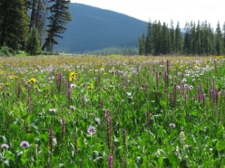
From the trailhead you can take longer hikes over to Washington Gulch or to the summit of the mountain. To hike through fields of flowers in bloom and groves of quaking aspen follow the dirt road up to the fence line and turn right through the aspens gradually descending through masses of flowers.
 In the open meadows you will be waist-high in masses of flowers at the peak; Lupine, Corn Husk Lilies, Little Sunflowers,
Penstemon, Prairie Smoke, Larkspur, Sneezeweed,
Indian Paintbrush, Scarlet Gilia, Wild Geraniums, Osha, Creamy
Buckwheat, Wild Onions, and many more.
In the open meadows you will be waist-high in masses of flowers at the peak; Lupine, Corn Husk Lilies, Little Sunflowers,
Penstemon, Prairie Smoke, Larkspur, Sneezeweed,
Indian Paintbrush, Scarlet Gilia, Wild Geraniums, Osha, Creamy
Buckwheat, Wild Onions, and many more.
In the aspen are many other different species;
Tall Chiming Bells, Subalpine Larkspur, Sweet Cicely, Glacier Lilies,
Spring Beauties, Meadowrue, Cow Parsnip, Fendler Waterleaf, to name
just a few.
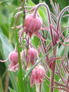
Photo: Prairie Smoke, June 27th
Photo: Masses of Mule's Ears, July 5th
Some early bloomers.
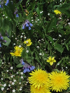
Fairy Candelabra, Chiming Bells,
Yellow Violets & Dandelions, June 3rd
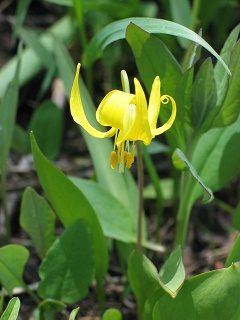
Glacier Lily, June 14th
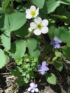
Wild Strawberry & Blue Violets,
June 9th
Lily Lake
Distance: 4 miles
Difficulty:
Moderate
Trail Type:
Out and back
Elevation Gain: 475 feet
Starting Elevation: 9,930 feet
Popularity:
Minor
Best time for flowers:
July, August
Getting there:
Drive 6 miles west from Crested Butte on the Kebler Pass Road. Take the left fork signed to Ohio Pass and Gunnison.
Continue a mile to the trailhead parking on the left, before Ohio
Pass.
This higher altitude trail can still be covered in snow in July because of the trees. The steepest part of the trail is at the beginning. It ascends through subalpine forests and meadows carpeted in wildflowers to a pretty lake surrounded by mountains where pond lilies bloom and salamanders swim. In mid-July I have identified over 80 species on the trail. If you continue past the lake instead of returning the way you came up, the old logging road will take you to Splain's Gulch.
 In the forest you
may see Twisted Stalk, Heart-leafed Arnica,
Canada Violets, Subalpine Jacob's Ladder, Small-flower Miterwort and Pygmy Bitterroot.
In June the meadows are carpeted with Blue Violets and Buttercups. If the snow
is still melting there will be masses of Glacier Lilies and Spring
Beauties. The lilies bloom
toward the end of July and Elephant Heads, Falsegold Groundsel, Subalpine Daisies, Queen's
Crown and Bistort fill the meadow by
the lake.
By August the rich purple of Fringed Gentians color the landscape.
In the forest you
may see Twisted Stalk, Heart-leafed Arnica,
Canada Violets, Subalpine Jacob's Ladder, Small-flower Miterwort and Pygmy Bitterroot.
In June the meadows are carpeted with Blue Violets and Buttercups. If the snow
is still melting there will be masses of Glacier Lilies and Spring
Beauties. The lilies bloom
toward the end of July and Elephant Heads, Falsegold Groundsel, Subalpine Daisies, Queen's
Crown and Bistort fill the meadow by
the lake.
By August the rich purple of Fringed Gentians color the landscape.
Photo: Fringed Gentian & Queen's Crown, July 22nd Photo: Meadow by the lake, July 17th
Some of the wildflowers found on the trail.
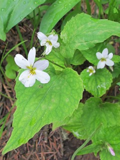
Canada Violet, July 9th
Subalpine Jacob's Ladder,
June 25th
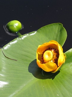
Yellow Pond Lily,
July 25th
Poverty Gulch

Distance: Up to you, 2 miles to the stream crossing
Difficulty:
Moderate to strenuous
Trail Type:
Out and back
Elevation Gain:1,852 feet
to Daisy Pass, 500 feet to stream crossing
Starting Elevation: 9,790 feet
Popularity:
Moderate
Best time for flowers:
Mid-July to mid-August
Getting there:
Drive north out of Crested Butte on the Gothic Road less than 1 mile,
turn left at the Slate River Road. Drive 7 miles to Pittsburg and
just beyond is the Daisy Pass trailhead on the left. Most years it is
possible to drive across the river with 4WD and park further up the road.
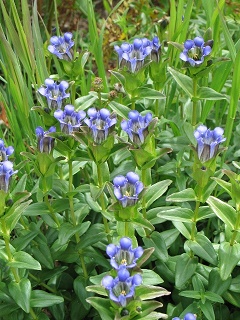
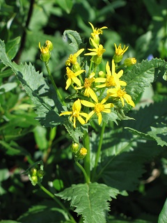
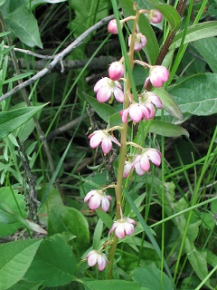
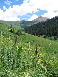
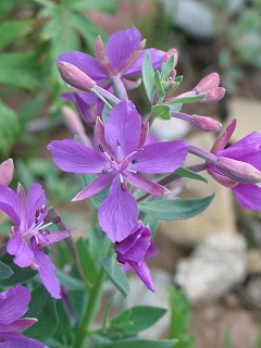
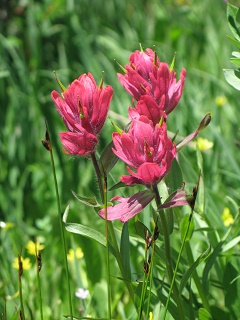
My personal best for wildflowers on one hike was 118 species on this trail, without going alpine; 80+ is not unusual. The trail takes you through the montane and subalpine zones in moist, open, rocky and forested environments; a great diversity of wildflowers. The flowers are at their peak in mid-July. At the beginning of the trail look to your left to see waterfalls. About 2 miles from the Slate River the road will meet Poverty Creek. You can enjoy the waterfalls and abundance of flowers near the creek, or you can continue on the road up to Augusta Mine, or you can cross the stream and follow the old road to the left into Baxter Basin and up to Daisy Pass and Cascade Mountain, for more amazing wildflower displays.
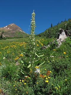 Along the trail you may see
Monument Plants, Mountain Death Camus, Pearly Everlasting, King's Crown, Bistort, Fringed Grass-of-Parnassus,
Fremont's
Groundsel, Slender Hawkweed, Yellow
Along the trail you may see
Monument Plants, Mountain Death Camus, Pearly Everlasting, King's Crown, Bistort, Fringed Grass-of-Parnassus,
Fremont's
Groundsel, Slender Hawkweed, Yellow 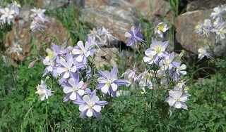 Monkeyflower, Spreading Dogbane, Coyote Mint,
Giant Hyssop, Colorado Columbine, Case's Fitweed, Monkshood,
Chiming Bells, Bog Saxifrage, Bog Orchids, Elephant
Heads, Shrubby Cinquefoil, Sneezeweed, Wyoming Paintbrush, Dusty Maiden, Alpine Sorrel, Bunny-in-the-Grass,
Scree Penstemon, Yellow Violet, Ballhead Waterleaf, to name just a few.
In a wet area about a mile up the trail is a mass of Monkshood. Further
along in a moist area Case's Fitweed grows, endemic to this area of Colorado although common in the Pacific Northwest.
Monkeyflower, Spreading Dogbane, Coyote Mint,
Giant Hyssop, Colorado Columbine, Case's Fitweed, Monkshood,
Chiming Bells, Bog Saxifrage, Bog Orchids, Elephant
Heads, Shrubby Cinquefoil, Sneezeweed, Wyoming Paintbrush, Dusty Maiden, Alpine Sorrel, Bunny-in-the-Grass,
Scree Penstemon, Yellow Violet, Ballhead Waterleaf, to name just a few.
In a wet area about a mile up the trail is a mass of Monkshood. Further
along in a moist area Case's Fitweed grows, endemic to this area of Colorado although common in the Pacific Northwest.
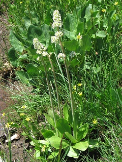
Photo: Colorado Columbine, August 2nd Photo: Monument Plant, July 22nd
Some less common wildflowers found on the trail.
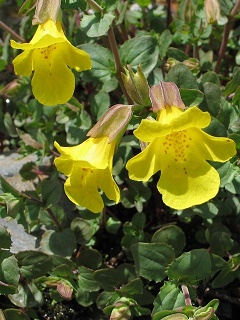
Yellow Monkeyflower, July 4th
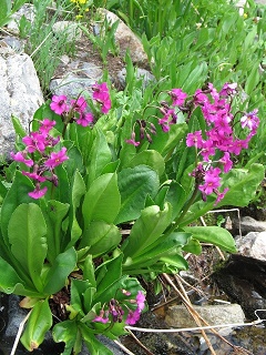
Parry's Primrose, July 31st
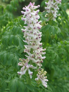
Case's Fitweed, July 11th
Lake Irwin

Distance: 2+ miles
Difficulty:
Easy
Trail Type:
Loop
Elevation Gain: 98 feet
Starting Elevation: 10,330 feet
Popularity:
Moderate, busy near the campground
Best time for flowers:
July and August
Getting there:
Drive 6 miles west from Crested Butte on the Kebler Pass Road. Take the
right turn to Lake Irwin Campground and drive 2.5 miles and park by the lake.
Although at higher elevation this is a fairly flat trail around the lake passing through a variety of habitats including dense conifer forest, lush meadows, and wetlands making for a wide variety of wildflowers. It feels adventurous, without feeling too arduous, to walk around a lake. The area in front of the campground on the west side of the lake is usually busy with people fishing, boating and paddling but the rest of the trail is much quieter. At the north end of the lake is a waterfall and a creek to cross.
 You will be up to your shoulders in Little Sunflowers, Osha,
Corn Husk Lilies,
Lupine, Monument Plants and Arrow-leaved Ragwort. You may see Leafy Jacob's Ladder,
Colorado Columbine, King's Crown, Bog Wintergreen, Parry Gentian, Rosy
Paintbrush, Blue Violets, Canada Violets, Meadowrue, Tall Chiming Bells, Scarlet Gilia, Bog Saxifrage, Bog Orchids,
Elephant Heads, Plantain-leaf Buttercups, Shrubby Cinquefoil, Mountain Parsley, Wild Roses, Sneezeweed, Wild
Geranium, Penstemon, amongst
many others.
You will be up to your shoulders in Little Sunflowers, Osha,
Corn Husk Lilies,
Lupine, Monument Plants and Arrow-leaved Ragwort. You may see Leafy Jacob's Ladder,
Colorado Columbine, King's Crown, Bog Wintergreen, Parry Gentian, Rosy
Paintbrush, Blue Violets, Canada Violets, Meadowrue, Tall Chiming Bells, Scarlet Gilia, Bog Saxifrage, Bog Orchids,
Elephant Heads, Plantain-leaf Buttercups, Shrubby Cinquefoil, Mountain Parsley, Wild Roses, Sneezeweed, Wild
Geranium, Penstemon, amongst
many others.
Photo: Bog Saxifrage & Plantain-leaf Buttercups, July 16th
Photo: Corn Husk Lilies, July 30th
Some of the wildflowers found on the trail.
Parry Gentian, September 3rd
Arrow-leaved Ragwort, July 20th
Bog Wintergreen,
July 30th
Hasley Basin
Distance: 6 miles
Difficulty:
Moderate
Trail Type:
Out and back
Elevation Gain: 1,600 feet
Starting Elevation:
10,400 feet
Popularity:
Very popular until Hasley turnoff, then minor
Best time for flowers:
Mid-July to August
Getting there:
Drive 8 miles north from Crested Butte to Gothic. Continue for another
6.3 miles past Emerald Lake and over Schofield Pass then over a small bridge to the West Maroon trailhead on the right.
This trail will take you all the way to Aspen over West Maroon Pass, to Frigid Air Pass or to Hasley Basin, which is the shortest and least crowded hike. This can be done as a loop, see the Hiking Guide, but I prefer to go up to the highest point and return the same way. There are spectacular masses of wildflowers all the way. It is hard to describe the beauty. See the photo at the top of the page.
 The trail starts in forest, passes
the remains of an old cabin then switchbacks up out of the trees onto mountainsides
carpeted with flowers. When the trail forks after about
2 miles, take the left. The trail to the right is a steep
trail to West Maroon Pass. The trail up to Hasley
Basin is steep switchbacks and you will reach the high point after another mile and have fantastic
panoramic views of the Maroon Bells-Snowmass Wilderness. You will see Subalpine Arnica, American Bistort, Wyoming Paintbrush,
Little Sunflowers, Subalpine Daisies, Monument Plants, Sneezeweed, Lupine, Osha, Colorado Columbine, Fireweed, Corn Husk Lilies, Rosy Paintbrush,
Mountain Sorrel, Brook Saxifrage, River Beauty, Gordon's Ivesia, and many more.
The trail starts in forest, passes
the remains of an old cabin then switchbacks up out of the trees onto mountainsides
carpeted with flowers. When the trail forks after about
2 miles, take the left. The trail to the right is a steep
trail to West Maroon Pass. The trail up to Hasley
Basin is steep switchbacks and you will reach the high point after another mile and have fantastic
panoramic views of the Maroon Bells-Snowmass Wilderness. You will see Subalpine Arnica, American Bistort, Wyoming Paintbrush,
Little Sunflowers, Subalpine Daisies, Monument Plants, Sneezeweed, Lupine, Osha, Colorado Columbine, Fireweed, Corn Husk Lilies, Rosy Paintbrush,
Mountain Sorrel, Brook Saxifrage, River Beauty, Gordon's Ivesia, and many more.
Photos: August 14th
Some wildflowers seen on the trail in the subalpine zone.
River Beauty, August 14th
Subalpine Arnica, August 14th
Rosy Paintbrush,
July 16th
Crested Butte Mountain
Distance: 2 to 10 miles
Difficulty:
Moderate, strenuous to the summit
Trail Type:
Up and down
Elevation Gain:
1,200 feet from lift to summit
Starting Elevation:
9,350 feet
at base area, 11,430 feet at top of lift
Popularity: Popular
Best time for flowers:
July, August
Getting there:
Drive or take the shuttle from Crested Butte to
the ski area.
An easy way to see alpine flowers is to take the Silver Queen lift from the ski area, or you can hike up 3 miles. It is a strenuous hike with an elevation gain of 2,700 feet from the base area to the summit. At the top of the lift there is a trail to the summit at 12,162 feet. The last section is over rocks and there are few flowers.
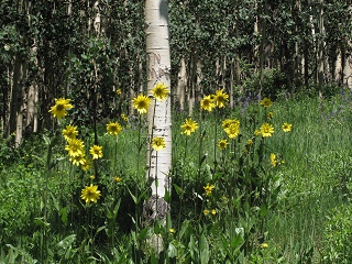 There
are also many trails on the flanks of the
There
are also many trails on the flanks of the  mountain where aspen forests and meadows are
full of montane flowers; lupine, sunflowers, columbine, and many more.
You can explore the area at the top of the lift then start on the trail to the summit
which climbs above tree line. When you reach the saddle there is a big area to explore and find many
varieties of alpine flowers, or you can continue on to the summit.
You may see Mountain Dryad, Snowball Saxifrage, Sulphur Paintbrush, Pussytoes, Moss Campion, Alpine Clover, Alpine Avens,
Whitestem Goldenbush, Arctic Willow, Alpine Sorrel, Alpine Smelowskia, Alp Lily, Tall Blacktip Ragwort, and more.
mountain where aspen forests and meadows are
full of montane flowers; lupine, sunflowers, columbine, and many more.
You can explore the area at the top of the lift then start on the trail to the summit
which climbs above tree line. When you reach the saddle there is a big area to explore and find many
varieties of alpine flowers, or you can continue on to the summit.
You may see Mountain Dryad, Snowball Saxifrage, Sulphur Paintbrush, Pussytoes, Moss Campion, Alpine Clover, Alpine Avens,
Whitestem Goldenbush, Arctic Willow, Alpine Sorrel, Alpine Smelowskia, Alp Lily, Tall Blacktip Ragwort, and more.
Photo: Moss Campion & Alpine Phlox, July 2nd
Some denizens of the alpine zone.
Alpine Forget-me-not,
July 2nd
Snowball Saxifrage,
July 21st
Alpine Ragwort,
July 21st
Scarp Ridge
Distance: 4.6 miles
Difficulty:
Moderate but altitude makes it challenging
Trail Type:
Loop
Elevation Gain: 1,576 feet
Starting Elevation: 10,712 feet
Popularity: Moderate
Best time for flowers:
July, August
Getting there:
Drive 6 miles west from Crested Butte on the Kebler Pass Road. Take the
right turn to Lake Irwin Campground and drive 2.5 miles and past the lake for another 1/2 mile. Bear right toward Irwin Lodge
and park on the right side of the road. Continue up the road on foot to the trailhead.
This hike will give you more spectacular views and meadows of subalpine flowers on the way to more alpine flowers. The objective is the ridge for the views which can be reached out and back or as part of a loop. Take the right fork to hike counter clockwise for a gradual incline and steep decline. Take the left fork for a steeper but shorter route to the ridge and a clockwise hike to decline gradually.
 The
views from the ridge are outstanding,
The
views from the ridge are outstanding,
 as are the huge variety of flowers
growing in the tundra. You may see Golden Draba, Mountain Harebell, Parry Clover,
Scarlet Paintbrush, Parry's Lousewort, Purple Fringe, Kings Crown,
Gordon's Ivesia, Alpine Avens, Tundra Paintbrush, Alpine Chickweed, Cutleaf Daisy,
Boreal Sandwort, Rocky Mountain Sagewort, Alpine Clover, Sibbaldia, and more.
as are the huge variety of flowers
growing in the tundra. You may see Golden Draba, Mountain Harebell, Parry Clover,
Scarlet Paintbrush, Parry's Lousewort, Purple Fringe, Kings Crown,
Gordon's Ivesia, Alpine Avens, Tundra Paintbrush, Alpine Chickweed, Cutleaf Daisy,
Boreal Sandwort, Rocky Mountain Sagewort, Alpine Clover, Sibbaldia, and more.
Photo: Old-Man-of-the-Mountain, July 12th Photo: Lupine & Scarlet Paintbrush, July 14th
More denizens of high elevation.
Purple Fringe, July 14th
Gordon's Ivesia & Cutleaf Daisy,
July 24th
Kings Crown, July 14th
Three Lakes Trail
Distance:
2.8 miles
Difficulty:
Moderate
Trail Type:
Loop
Elevation Gain:
578 feet
Starting Elevation:
9,612 feet
Popularity:
Moderate
Best time for flowers:
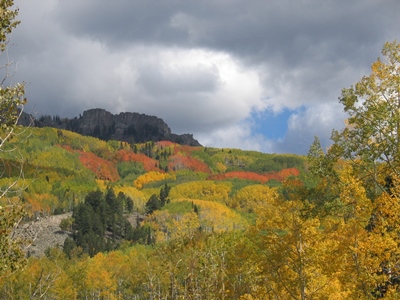
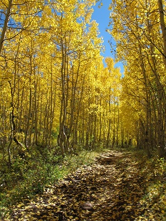
July, late September for leaves
Getting there:
Drive west out of Crested Butte on the Kebler Pass Road for
16.9 miles. Turn left for the Lost Lake Campground and drive 2 miles up to park
on the right just before the lake.
 This last hike is not for the flowers; it is for
the magnificent drive through the aspens and the very scenic hike past waterfalls and lakes. The leaves are at their
colorful peak in the last week
This last hike is not for the flowers; it is for
the magnificent drive through the aspens and the very scenic hike past waterfalls and lakes. The leaves are at their
colorful peak in the last week 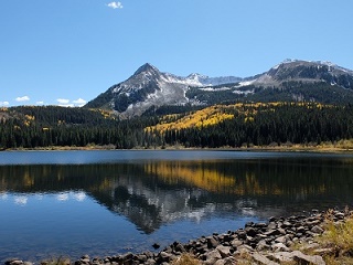 of September
into October. The hike is a loop past three pretty lakes
with panoramic views of Marcellina and Beckwith Mountains.
If you go counter-clockwise the climb is more gradual. Look for the
trail marker on the west side of the campground. After skirting around
Lost Lake the trail climbs up to Dollar Lake, a lovely spot for lunch.
It continues on past a waterfall, worth a little detour, then joins the
Beckwith Pass trail before descending down to the Lake through a
forest of golden aspen.
of September
into October. The hike is a loop past three pretty lakes
with panoramic views of Marcellina and Beckwith Mountains.
If you go counter-clockwise the climb is more gradual. Look for the
trail marker on the west side of the campground. After skirting around
Lost Lake the trail climbs up to Dollar Lake, a lovely spot for lunch.
It continues on past a waterfall, worth a little detour, then joins the
Beckwith Pass trail before descending down to the Lake through a
forest of golden aspen.
Photo: Beckwith Mountain reflected in Lost Lake Slough
Finally...
However short your walk in the quest for wildflowers, don't forget sun protection, rain gear, good footwear, water and sometimes bug-spray. Please don't litter. Please do not pick the flowers, however prolific they appear. All the photographs were taken from the trail, so please stay on the trail. If you come to a gate, leave it as you found it. Respect 'No Trespassing' signs. Enjoy!